Lower Nanticoke River Watershed Plan Request for Proposals
Nanticoke Watershed Alliance
Lower Nanticoke River Watershed Plan
Request for Proposals
DUE: January 16th, 2026
Background Information
The mission, goals, and objectives of the Nanticoke Watershed Alliance (NWA) are developed by consensus with our partnership. The Alliance includes partners from Maryland and Delaware, including representatives from industry, agriculture, environment, business, community, state, local, and federal governmental organizations.
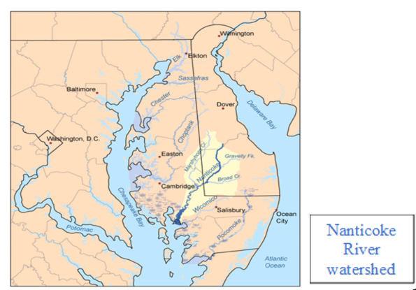
The Nanticoke River is a 64-mile river that begins in southern Delaware and flows southwest into the Eastern Shore of Maryland, emptying into the Chesapeake Bay. One of the Chesapeake’s healthiest rivers, the Nanticoke’s 725,000-acre watershed provides excellent habitat of significance for many nationally threatened plants and animals. The Nanticoke is the most biologically diverse watershed on Delmarva and supports excellent fisheries. It has a rich history, with many historic buildings and resources, and the northernmost stands of bald cypress on the Atlantic Coast. It also has the highest concentration of Bald Eagles in the northeastern United States.
NWA’s Mission: Fostering partnerships and progress in conserving the natural, cultural, and recreational resources of the Nanticoke River Watershed through dialogue, collaborative outreach and education.
NWA’s Core Values:
- Conservation– The health of the Nanticoke River watershed is paramount.
- Collaboration– We embody partnership through action.
- Communication– We value diverse voices and viewpoints where all have a place at the table. We embrace constructive, open dialog as a means to problem solving.
- Scientific integrity– We rely on sound science to assess the health of the watershed and share information with the community.
- Education– We are committed to sharing with others the importance of conserving the watershed.
The NWA has five full time employees that coordinate a wide variety of projects and programs. Visit www.NanticokeRiver.org to learn more.
Scope of Services
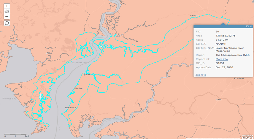
The Nanticoke Watershed Alliance, working with Wicomico County Department of Public Works (partner), the Town of Mardela Springs (partner), and University of Maryland, Lower Eastern Shore Research and Education Center (LESREC), Poplar Hill Facility (Supporter/Cooperator), is requesting proposals to develop a watershed-based plan (WBP) for the Lower Nanticoke River watershed. The Lower Nanticoke River watershed identified represents 34,512 acres (54 square miles), the large majority of which is located on the east side of the river in Wicomico County, MD. Another portion is located west of the river in Dorchester County, MD.
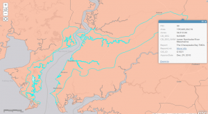 Lower Nanticoke Mesohaline or NANMH in the Maryland Department of Environment (MDE)’s map of Chesapeake Bay total maximum daily load (TMDL) watersheds
The goal is to produce an a – i watershed-based plan that meets the requirements of and is approved by the U.S. Environmental Protection Agency (EPA) for §319(h) grant implementation funding and that will be used to identify and guide implementation projects resulting in observable improved water quality in the Lower Nanticoke River watershed. This project will identify and prioritize potential restoration / improvement projects within the respective watershed for implementation by NWA and others. In addition, projects that may be eligible for 319(h) funds will be identified for use in submitting grant applications.
The watershed-based plan will fulfill the nine essential elements, a – i, for effective watershed-based planning as detailed in the EPA’s Handbook for Developing Watershed Plans to Restore and Protect Our Waters. EPA’s nine elements are as follows:
- Identify and quantify sources of pollution in watershed
- Identify water quality target or goal and pollutant reductions needed to achieve goal
- Identify the best management practices (BMPs) that will help to achieve reductions needed to meet water quality goal/target
- Describe the financial and technical assistance needed to implement BMPs identified
- Describe the outreach to stakeholders and how their input was incorporated and the role of stakeholders to implement the plan
- Estimate a schedule to implement BMPs identified in plan
- Describe the milestones and estimated time frames for the implementation of BMPs
- Identify the criteria that will be used to assess water quality improvement as the plan is implemented
- Describe the monitoring plan that will collect water quality data need to measure water quality improvement
Any relevant existing data will be integrated with the new data gathered for characterizing the watershed and identifying impairments and potential restoration opportunities that also factor in changing weather conditions in the watershed. For both the watershed plan development and future implementation projects, strategies that address changing weather conditions will be identified and incorporated using documents such as the MD Department of Natural Resources’ Next Generation Adaptation Plan and the Adaptation Framework for guidance and reference. Feedback and input from the public will be integrated into all phases of this project to tailor the needs and wants of the community members to the plan and to the culminating on-the-ground actions and practices employed. Outreach to the agricultural community will be done in concert with our current partners such as Delmarva Chicken Association and Wicomico County Department of Public Works, and through our working relationships with organizations such as the College of Agriculture & Natural Resources (University of Maryland’s Lower Eastern Shore Research and Education Center), and Lower Shore Land Trust.
Restoration/Enhancement opportunities will be identified in the following major categories:
- Stream/Riparian Buffers/Floodplains/Living Shorelines
- Ditches (roadside, agricultural, tax, private)
- Wetlands
- Agricultural Best Management Practices
- Urban Stormwater Retrofits
- Urban Sub-watershed Site Reconnaissance
NWA’s 15-year report card included data for this target area from 2008-2022 collected by our Nanticoke Creekwatchers volunteers: https://nanticokeriver.org/15yrc/ The Creekwatchers data is federally approved Tier 3 data which means it can be used for policy and management decisions. We observed and measured disturbing changes at the Quantico Creek site, which is included in the geographic area identified in this project, during 2022 monitoring. The site showed broad declines in every parameter except for dissolved oxygen. We also saw continued issues related to excessive nutrients in the Rewastico Creek system which is just north of Quantico Creek. In spite of some gains in the lower creeks and lower Nanticoke River, sites along the Rewastico, Barren (just north of Rewastico Creek), and Quantico Creeks continue to be heavily impaired. NWA is motivated to address this significant decrease in water quality, focusing initial efforts in the Quantico Creek subwatershed and the rest of the Lower Nanticoke River watershed through this project.
The highly qualified contractor selected will work with the Nanticoke Watershed Alliance, stakeholders, other partners/supporters and interested parties to the project, to develop and finalize the WBP for EPA review by February 15, 2027.
Services must include:
1. Organizing/Conducting a kick-off meeting with all partners, supporters, stakeholders, and other interested parties to discuss/review their roles in the project, as well as the project goals, scope, and schedule.
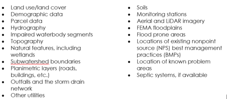
2. Gathering & reviewing of relevant data such as spatial data, water quality data collected by NWA and others, and watershed studies and reports, such as county Watershed Implementation Plans and local TMDL documents. GIS data to be gathered includes but is not limited to:
3. Charactering the watershed by summarizing the physical and natural features, land use, waterbody and watershed conditions, pollutant sources and loads, on a watershed and subwatershed basis.
4. Modeling of pollutant load to determine the load reductions required to address the watershed TMDLs and impairments. The Lower Nanticoke watershed is subject to nitrogen, phosphorus, and sediment loads reduction requirements of the Chesapeake Bay TMDL. One of two additional impairments requiring a TMDL identified in MDE’s 2024 Integrated Report is: sediment impairments for 1st through 4th order non-tidal stream in the entire Nanticoke River watershed. This plan will need to address the Chesapeake Bay TMDL and should also quantify load reductions toward the local sediment impairment.
Relevant TMDL documents are to be reviewed to quantify the required NPS reductions from each source. The Chesapeake Assessment and Scenario Tool (CAST) is to be used to quantify reductions from BMPs implemented since the TMDL baseline year. CAST is also to be used to estimate the load reductions from all BMPs proposed in this WBP.
5. Engaging key partners with established landowner relationships and local knowledge or who are leading restoration or conservation efforts in the watershed to help identify proposed management measures and an outreach strategy.
The contractor will assist NWA with public engagement by conducting outreach to key stakeholders such as MDE, Maryland Department of Natural Resources, Maryland Department of Agriculture, Wicomico County, Dorchester County, Natural Resources Conservation Service, county Soil Conservation Districts, and non-profits, such as the Lower Shore Land Trust, conducting relevant work in the watershed. This may take the form of a virtual stakeholder meeting or one-on-one conversations for the purpose of gathering input on specific water quality problem areas within the watershed and potential NPS management measures as well as ideas to support the development of a stakeholder outreach strategy for the watershed. The contractor will also support NWA by attending up to three site visits as needed to discuss conservation or restoration options with interested landowners.
6. Identifying and prioritizing NPS management measures to meet the pollutant load reduction requirements for the watershed. Prioritization will be based on the stakeholder input gathered (e.g., identified problems and types of BMPs that are applicable and publicly acceptable as solutions), a desktop analysis of BMP opportunity (based on acres of each land use type each BMP can be applied and current extent of implementation), and the cost-effectiveness (from CAST) of each BMP type to address the pollutants of concern. The contractor will also identify specific geographic priorities such as the portions of the watershed with local sediment and bacteria impairments where specific measures may be prioritized. BMPs that are likely to be applicable in this watershed include (but are not limited to) stream corridor BMPs such as riparian buffers, fencing, and stream and wetland restoration; septic system upgrades, tree planting, cover crops, synthetic fertilizer and manure management, and crop irrigation optimization. The contractor will use GIS and CAST to identify the proposed implementation level of each identified BMP and estimate the associated pollutant load reductions. CAST will also be used to estimate planning-level implementation costs for the suite of proposed BMPs.
7. Drafting a complete plan for the watershed using the results of the previous work and developing new content to satisfy elements f-i of EPA’s nine minimum elements:
- Estimate a schedule to implement BMPs identified in plan
- Describe the milestones and estimated time frames for the implementation of BMPs
- Identify the criteria that will be used to assess water quality improvement as the plan is implemented
- Describe the monitoring plan that will collect water quality data needed to measure water quality improvement
NWA will take the lead on development of the stakeholder outreach strategy and the monitoring plan to address future water quality data collection to measure ambient water quality improvements associated with plan implementation. The draft plan will be provided to NWA and the counties for review. The contractor will revise the plan to address these comments. NWA will submit the final plan to MDE and EPA for review and acceptance of the plan as eligible for Section 319 implementation funding. The contractor will make two rounds of additional revisions to the plan to address comments from MDE and EPA. The final plans will be submitted to NWA in electronic format along with all supporting data files.
Please Note:
- NWA will provide all available water quality data and assist with acquiring GIS data including acquiring information on NPS BMPs.
- NWA will lead the development of the public outreach strategy and monitoring components of the watershed plan
- NWA will coordinate site visits with landowners, ideally in 2-3 trips.
- No Quality Assurance Project Plan is needed for this project
- The final watershed plan will identify the proposed management measures, including units treated, and location within priority subwatersheds (if applicable) to achieve the pollutant reduction goals. Site-specific BMPs will be identified in a later phase through landowner outreach and site visits. A proposed strategy for this outreach will be included as part of the plan.
- As requested by MDE, the primary tool to quantify pollutant loads, required reductions, and reductions associated with proposed management measures will be CAST, to align with the Chesapeake Bay TMDL.
- Per MDE’s contract with NWA (Grantee):
“The Grantee may subcontract any portion of the grant with prior notice thereof to and approval from the Department. Any subcontractor(s) shall, and the Grantee shall require that any subcontractor(s) shall, provide to the Department upon request copies of any invoices, records, timesheets, work logs, contracts, or any other documents or information needed in order for the Department to comply with State or federal reporting and audit requirements.
The Grantee agrees to require any and all subcontractors retained by the Grantee in the course of performance of this Agreement to indemnify and save harmless and defend the State of Maryland, the Department, the Grantee, and all of their respective representatives from all suits, actions, or claims of any character, brought on account of any injuries or damage sustained by any person or property in consequence of any work performed under this Agreement, either by the Grantee or the Department, or any subcontractor, or their respective employees, agents, or representatives. This responsibility is not to be deemed as a waiver of any immunity, which may exist in any action against the Department or the Grantee.”
Evaluation Criteria
A review and selection committee made up of Nanticoke Watershed Alliance and project partners will evaluate the consultants based on the proposals submitted. If necessary, an oral interview may be conducted with submitting consultants.
Ranking of the Proposals will be based on the following point system (100 points maximum):
- Inclusion of all required items and completeness of the Proposal (5 points)
- Understanding of the work to be done (25 points)
- Previous experience of similar projects completed on time and within budget (20 points)
- Qualified and experienced personnel in the project team (15 points)
- Capability of exploring/using innovative or advanced techniques (10 points)
- Familiarity with county, state and federal procedures and related impacts to project (10 points)
- Commitment to adhering to the project schedule and budget (5 points)
- Clear description of the tasks and demonstrated technical ability (10 points)
Application Instructions
Interested companies are invited to submit a proposal by January 16th, 2026. The work described in the proposal is expected to be complete by February 15, 2027.
The proposal should include:
- Staff qualifications
- Proposal narrative
- Preliminary work plan and timeline
- Itemized budget
Maximum contractor compensation: $66,200
Proposals should be submitted to:
John Sandkuhler
Restoration Coordinator
Nanticoke Watershed Alliance
johnsandkuhler@nanticokeriver.org
410.622.3669